1. บทนำ
This manual provides essential information for the safe and efficient operation of your Leica Disto D5 professional laser distance meter. The Leica Disto D5 is a high-precision measuring device equipped with Bluetooth connectivity, a viewfinder camera, and an inclinometer, designed for both indoor and outdoor applications. It supports various measurement functions including height tracking, profile measurement, and angle measurement.
Please read this manual thoroughly before using the device to ensure proper handling and to maximize its capabilities.
2. ข้อมูลด้านความปลอดภัย
ความปลอดภัยของเลเซอร์: The Leica Disto D5 emits a Class 2 laser. Do not stare directly into the laser beam or direct it at other people. Avoid pointing the laser at reflective surfaces that could redirect the beam into eyes.
ความปลอดภัยทั่วไป:
- เก็บอุปกรณ์ให้ห่างจากเด็ก
- Do not attempt to disassemble or modify the device. This will void the warranty and could result in injury.
- ใช้เฉพาะแบตเตอรี่และอุปกรณ์ชาร์จที่ระบุไว้เท่านั้น
- Protect the device from extreme temperatures, moisture, and strong impacts.
3. เนื้อหาบรรจุภัณฑ์
ตรวจสอบว่ามีรายการทั้งหมดอยู่ในแพ็คเกจของคุณ:
- เครื่องวัดระยะเลเซอร์ Leica DISTO D5
- สายรัดข้อมือ
- กระเป๋าใส่อุปกรณ์ป้องกัน
- สาย USB
- ใบรับรองการสอบเทียบ

Image 3.1: Leica Disto D5 with included accessories: the device, a protective pouch, and a USB charging cable.
4. คุณสมบัติของผลิตภัณฑ์
The Leica Disto D5 incorporates advanced features for precise and versatile measurement tasks:
- บูรณาการ Viewfinder Camera: Enables target identification on the IPS display, even when the laser dot is not visible, ideal for outdoor use.
- Non-Contact Measurement Activation: Allows measurement initiation by briefly interrupting the laser path with your hand, preventing device movement and ensuring high accuracy.
- Flexible Data Transfer (Keyboard Mode): Connect the device to a computer to send measured values as keyboard input to various applications, such as Excel.
- ฟังก์ชั่นการวัดหลายรายการ: Includes Smart Horizontal Mode for measuring over obstacles, height tracking, profile measurement, and angle measurement.
- การเชื่อมต่อบลูทูธ: Facilitates seamless data transfer to the DISTO Plan App for documentation, creating floor plans, and sketches.
- การออกแบบที่ทนทาน: IP54 protection against dust and splash water, suitable for construction site environments.
- แบตเตอรี่ Li-Po แบบชาร์จไฟได้: Integrated lithium-polymer battery for extended use.
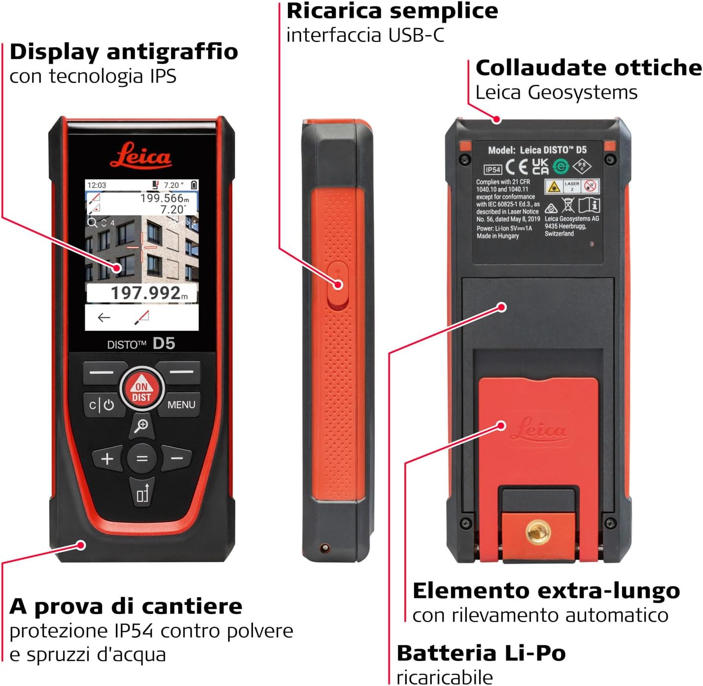
Image 4.1: Key features of the Leica Disto D5, highlighting its anti-scratch IPS display, USB-C interface for charging, IP54 protection, and rechargeable Li-Po battery.
5. การตั้งค่า
5.1. การชาร์จแบตเตอรี่
The Leica Disto D5 is powered by an integrated rechargeable Lithium-Polymer battery. Before first use, fully charge the device.
- Connect the provided USB cable to the USB-C port on the side of the device.
- เชื่อมต่อปลายอีกด้านหนึ่งของสาย USB เข้ากับอะแดปเตอร์ไฟ USB ที่ใช้งานร่วมกันได้ (ไม่รวมอยู่ด้วย) หรือพอร์ต USB ของคอมพิวเตอร์
- ไฟแสดงสถานะการชาร์จบนหน้าจอจะแสดงสถานะการชาร์จ
- เมื่อชาร์จเต็มแล้วให้ถอดสาย USB
5.2. เปิดเครื่องครั้งแรก
กดปุ่ม เปิด/DIST กดปุ่มเพื่อเปิดเครื่อง หน้าจอจะสว่างขึ้น และอุปกรณ์จะพร้อมใช้งาน
6. คู่มือการใช้งาน
6.1. Basic Distance Measurement
- ชี้ลำแสงเลเซอร์ไปที่เป้าหมายที่ต้องการ
- กดปุ่ม เปิด/DIST กดปุ่มหนึ่งครั้งเพื่อเปิดใช้งานเลเซอร์
- กดปุ่ม เปิด/DIST กดปุ่มอีกครั้งเพื่อทำการวัด ระยะทางที่วัดได้จะแสดงบนหน้าจอ

Image 6.1: Performing a basic distance measurement with the Leica Disto D5, showing the device held against a surface.
6.2. การใช้ Viewfinder Camera for Outdoor Measurements
For outdoor measurements or when the laser dot is difficult to see, the integrated viewfinder camera assists in targeting.
- Activate the device. The display will show the camera view.
- Aim the device so the target appears within the reticle on the IPS display.
- กดปุ่ม เปิด/DIST button to take the measurement.

Image 6.2: The Leica Disto D5 in use outdoors, demonstrating the viewfinder camera's ability to locate the laser point even in bright sunlight.
6.3. ฟังก์ชันการวัดขั้นสูง
The Leica Disto D5 offers several advanced functions accessible via the เมนู ปุ่ม.
- Smart Horizontal Mode: Measures horizontal distances even when obstacles are present.
- Height Tracking: Determines heights by taking multiple measurements.
- โปรfile การวัด : Captures a series of measurements to define a profile.
- การวัดมุม: Utilizes the inclinometer to measure angles.
Refer to the on-screen prompts and the full digital manual for detailed instructions on each function.
6.4. Data Transfer via Bluetooth and DISTO Plan App
The device can transfer measurement data wirelessly to the Leica DISTO Plan App on your smartphone or tablet.
- Ensure Bluetooth is enabled on your mobile device and the Disto D5.
- Download and install the Leica DISTO Plan App from your device's app store.
- Open the app and follow the instructions to pair with your Disto D5.
- Once connected, measurements can be sent directly to the app for documentation, creating floor plans, and sketches.
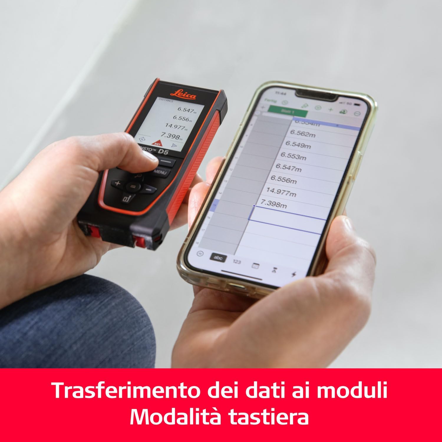
Image 6.3: Data transfer from the Leica Disto D5 to a smartphone using Bluetooth, showing measurements appearing in a digital form.
6.5. Keyboard Mode for Data Transfer
For direct integration with computer applications, use the keyboard mode:
- Connect the Disto D5 to your computer using the USB cable.
- Activate keyboard mode on the device (refer to the device's menu for this option).
- Open any application on your computer (e.g., Excel, Notepad) where you want to input data.
- Take a measurement with the Disto D5. The measured value will be automatically entered into the active field on your computer as if typed.
6.6. Non-Contact Measurement for Enhanced Precision
To minimize device movement during measurement and ensure maximum precision, utilize the non-contact activation feature.
- Mount the Disto D5 on a stable surface or tripod.
- Aim the laser at the target.
- Briefly pass your hand through the laser path to trigger the measurement without touching the device.

Image 6.4: Demonstrating non-contact measurement activation with the Leica Disto D5 on a tripod, ensuring high precision by avoiding physical contact during measurement.
7. การบำรุงรักษา
7.1. การทำความสะอาด
- ใช้ง.สะอาดนุ่มamp cloth to wipe the device. Do not use harsh chemicals or abrasive cleaners.
- For the lens and display, use a lint-free cloth specifically designed for optical surfaces.
7.2. การจัดเก็บ
When not in use, store the Leica Disto D5 in its protective pouch in a cool, dry place, away from direct sunlight and extreme temperatures.
8 การแก้ไขปัญหา
| ปัญหา | สาเหตุที่เป็นไปได้ | สารละลาย |
|---|---|---|
| เปิดเครื่องไม่ติด | แบตเตอรี่อ่อน อุปกรณ์ทำงานผิดปกติ | Charge the battery; if problem persists, contact support. |
| การวัดที่ไม่แม่นยำ | Unstable device; incorrect measurement reference point; environmental factors (e.g., strong sunlight, highly reflective surfaces) | Ensure device is stable; check reference point settings; use viewfinder camera for outdoor use; avoid highly reflective targets. |
| ปัญหาการเชื่อมต่อบลูทูธ | Bluetooth off on device/phone; device not paired; app issues | Ensure Bluetooth is on; re-pair devices; restart app/device. |
9. ข้อมูลจำเพาะ
| ข้อมูลจำเพาะ | รายละเอียด |
|---|---|
| หมายเลขรุ่น | D5 |
| ขนาด | 14.38 x 5.99 x 2.39 ซม. |
| น้ำหนัก | 176.9 กรัม |
| แหล่งพลังงาน | แบตเตอรี่ลิเธียมโพลิเมอร์ 1 ก้อน (รวมอยู่ด้วย) |
| เล่มที่tage | 1.5 โวลต์ |
| วัสดุ | พลาสติก |
| สี | สีแดง |
| ระดับการป้องกัน | IP54 (ป้องกันฝุ่นและละอองน้ำ) |
| การเชื่อมต่อ | บลูทูธ |
| ช่วงการวัด | สูงสุด 200 เมตร (ประมาณ 656 ฟุต) |
| ความแม่นยำ | ±1 มม. |
| Inclinometer Range | 360° (±0.2°) |

Image 9.1: Visual summary of Leica Disto D5 specifications, including range, accuracy, inclinometer, Bluetooth, and weight.
10. การรับประกันและการสนับสนุน
Leica Geosystems products are manufactured to the highest quality standards. For warranty information and technical support, please refer to the official Leica Geosystems webไซต์หรือติดต่อตัวแทนจำหน่ายในพื้นที่ของคุณ
แหล่งข้อมูลออนไลน์: For additional information, FAQs, and software updates, visit the official Leica Geosystems support page: Leica Geosystems Support


